
Dark Vessel partnership between MDA and Department of Fisheries and Oceans shows potential of commercial satellite data

Space technology company MDA is partnering with the Department of Fisheries and Ocean and the Department of National Defense on a $7-million project to detect and track illegal fishing boats.
The first use of the technology will be in the waters surrounding the Galapagos Islands, where a large fleet of Chinese fishing vessels — along with fishing boats of other nationalities — have gathered near waters that fall under Ecuadorian jurisdiction.
The Canadian government will be providing satellite data to the Ecuadorian navy along with building capacity among their staff to analyze the data and use it to intercept suspicious vessels, said Sean Wheeler, senior program officer at the Department of Fisheries and Oceans international program, in an interview with Research Money.
“We're funding the platform, which MDA is the prime contractor on. Canada has a long history in space-based surveillance through the RADARSAT program,” Wheeler noted.
MDA will be using its RADARSAT-2 satellite to find boats that have turned off their identification systems and may be fishing in areas that are legally off-limits. The project demonstrates the potential of commercial satellite data, as more companies have begun to offer data services to governments around the world.
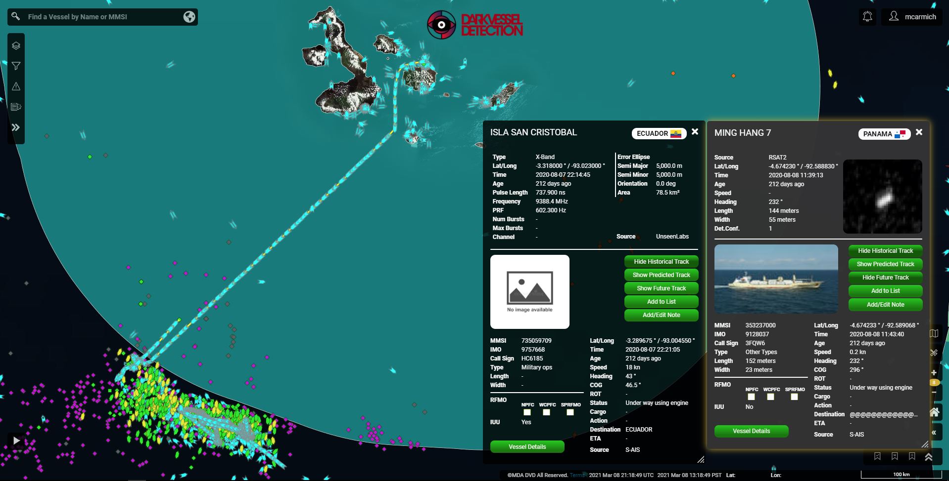 An image of the Chinese fishing fleet gathered outside of Ecuadorian waters near the Galapagos Islands in the Pacific Ocean. The purple dots represent "dark" vessels that have turned off their identification systems, according to Mark Carmichael, the director of product, geointelligence, at MDA.
Illegal, unreported and unregulated (IUU) fishing is a major contributor to the decline in fish stocks and the destruction of fish habitats. Wheeler said it is estimated that IUU fishing may be responsible for 30 percent or more of the caught fish worldwide. The Galapagos Islands are a UNESCO World Heritage site, and there is “intense local concern” on the islands about practices such as shark finning, Wheeler said.
Satellite data released by the company Hawkeye 360 has documented boats from a Chinese fishing fleet appearing to disable their UN-mandated automatic identification system (AIS) near the islands to hide their location as well as evidence that boats were fishing illegally within Ecuador’s exclusive economic zone (EEZ).
Mark Carmichael, the director of product, geointelligence at MDA, told Research Money that they made the announcement the moment that the operational campaign started, but they’ve been building the Dark Vessel Detection project for the last 18 months.
“They wanted to build a capability that would integrate all sources of space-based maritime domain awareness into a single platform, fuse the data, extract information on which vessels pose a threat on illegal fishing and allow the users of the capability to know exactly which vessels to target with their in-theatre assets,” Carmichael explained.
“A country like Ecuador may have a small navy, relatively speaking. They don’t have time to search every single vessel.”
Canada signed a memorandum of understanding with Ecuador in December 2020 to formalize a partnership to improve surveillance around the islands. The funding is part of a larger $11.7M commitment to combat IUU fishing, made at the June 2018 G7 Summit in Charlevoix, Que. and announced in Halifax later that year.
Layering datasets is key to the project
MDA has owned the RADARSAT-2 satellite since it was launched in 2007, and most of the datasets to be used in the project have already existed for some time. What’s new about the project, according to Wheeler, is the way that data can be layered and analyzed for insights.
The International Maritime Organization requires large vessels to have an identification system on board, which is called an AIS transponder. The vessels that turn the transponder off may be involved in illegal activities, so data from satellites — such as radar imagery and ELINT data that can be used to geolocate vessels based on their radar emissions — can be compared with AIS data to detect the boats that are “dark” and may be involved in illegal activities.
"It's about layering all of these different data services,” Wheeler said. With many different datasets, they can not only detect which boats have turned off their AIS transponders, but also the chlorophyll in the water to predict where fish will gather and heat surface signatures to detect bright light.
"Squid fisheries, for example, use intense light to bring squid to the surface. And that's actually detectable through weather satellites."
The Department of Fisheries and Oceans is working with the Department of National Defense on the project. Adrienne Turnbull, the portfolio manager of order domain awareness at the Canadian Safety and Security program at Defence Research and Development Canada (DRDC), said their role has been to assess the feasibility of the technology.
“That ability to have a bunch of dots in the water and to actually say which ones should be focused on — a lot of science goes into that,” Turnbull said. “We have funded some in the past. This was an opportunity to bring it all together in a project that we hope will have a good impact.”
Data to be commercialized, possibly sold to US Navy or other buyers
The technology for the Dark Vessel Detection program is going to be sold to customers — generally government agencies — more broadly this coming year. MDA hopes to commercialize the project's output in late 2020 and select customers will be getting early access to the platform on July 1, according to Carmichael.
“If you can solve the problem of IUU fishing, you’re really solving a lot of the other domain awareness problems,” Carmichael said. While the DVD project is highly focused on IUU fishing, MDA's new operationalized maritime insights capability will have a broader focus on defense and intelligence, he added.
“Narco-trafficking, smuggling, piracy, these are other difficult to solve challenges that this platform will help us to address," Carmichael said.
Carmichael points to a successful operation in the Pacific Ocean as a demonstration of the technology’s potential. In 2020, the Global Fishing Watch, a UK non-profit that makes fishing data from satellites available to the public, provided information to US, Canadian and Japanese marine agencies on potentially suspicious vessels.
Armed with that intelligence, the US Coast Guard vessel Douglas Munro boarded 11 boats in the North Pacific Ocean and found 14 potential violations of fish conservation measures. After the boardings, an entire fleet of 31 fishing boats fled 850 nautical miles west across the Pacific to escape further inspections, according to a report on the operation provided by Carmichael.
"It doesn't take a lot to change a pattern of behaviour," he said.
Last decade has seen a boom in commercial satellite data
The DVD is a relatively small investment, but it’s a sign of the increasing possibilities that come from layering commercially-available satellite data. Commercialization of space data in general is “exponentially increasing,” said Wheeler.
"The big game changer here in the last few years has been the advent of companies like SpaceX and Rocketlab,” Wheeler said.
“We're seeing capabilities that used to be state level coming down to commercial and ubiquitous. The next challenge is how we harness that data, layer it properly, and put it in front of an end user in a way that works. That's what we're doing through this project."
Wheeler says governments can now “springboard” from one dataset to another. “You can imagine the ability to detect the presence of a vessel using radar, but then take a picture of it using an optical satellite or track it following its lights. Those are all different satellite missions, so you need an ability to capitalize on all of these different companies that are just in the process of getting their systems online.”
At the moment, there are dozens of companies providing different data services that governments must investigate and evaluate beforehand. In the DVD project, MDA is contracting data services from other satellite companies, such as AIS data from the company exactEarth.
"You can liken it to something like Netflix, where there will be a market for an entity that can bring all of the different providers into one place because right now we're seeing small satellite missions pop up all over the world,” said Wheeler. “Countries that have an interest in something like environmental monitoring or illegal fishing, we have to track all of these companies and the pros and cons. At some point, there will be some consolidation.”
R$
| Organizations: | |
| People: | |
| Topics: |


Events For Leaders in
Science, Tech, Innovation, and Policy
Discuss and learn from those in the know at our virtual and in-person events.
See Upcoming Events
You have 0 free articles remaining.
Don't miss out - start your free trial today.
Start your FREE trial Already a member? Log in
By using this website, you agree to our use of cookies. We use cookies to provide you with a great experience and to help our website run effectively in accordance with our Privacy Policy and Terms of Service.